






THIS CONTENT IS BROUGHT TO YOU BY NILU - read more
No health risk in Norway from Canadian wildfires
Air quality in Toronto has reached record-low levels. However, the many wildfires burning across Canada this summer do not pose a health risk in Norway.

The 2026 Canadian wildfire season started a bit slower than in recent years. But by mid-July, the Canadian Interagency Forest Fire Centre (CIFFC) reports more than 850 wildfires raging across the country.

At the moment, there are more than 100 active wildfires in northern Ontario alone. According to IQAir, this has made Toronto’s air quality one of the worst in the world. Other large North American cities such as New York, Washington D.C., and Detroit are also affected.
Models and laser beams monitor the smoke
Researchers at NILU are following the Canadian wildfires with great interest – and using several different technologies.
Senior researcher Sabine Eckhardt explains that they use a model that simulates atmospheric transport towards Europe. The model, called FLEXPART, tracks carbon monoxide (CO) and smoke particles emitted by the wildfires.
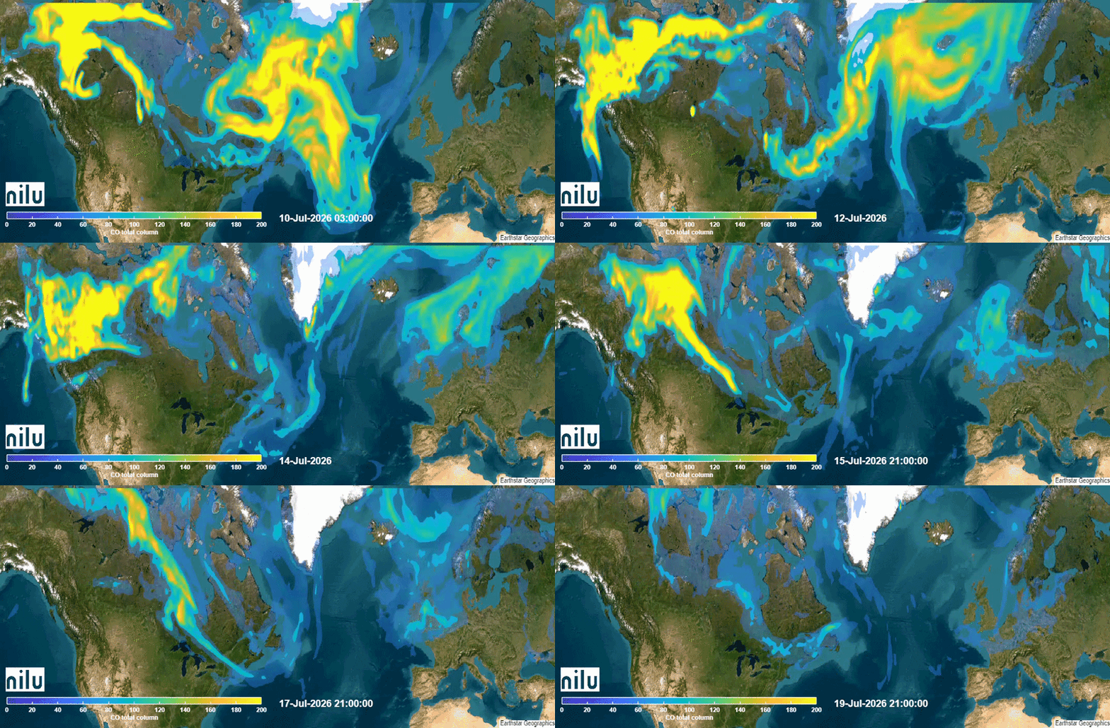
The Birkenes observatory in the south of Norway has also detected a signal caused by smoke particles from the fires.
'Sees' particles using a laser beam
Carbon monoxide and aerosols from wildfires can travel through the atmosphere over long distances. They can even cross continents – in this case, from Canada to Norway.
This allowed senior researcher Kerstin Stebel to detect the smoke signal above the Birkenes observatory using a ceilometer, also known as a cloud height meter.

“Very simply put, a ceilometer can see particles in the air by sending up a laser beam. It then analyses the reflected signal from the particles. On July 15th, the smoke layers were visible at an altitude of around 2.5 kilometres,” she says.

Not as extreme as in 2023
So far in 2026, 150 megatonnes of biomass have gone up in smoke. Senior researcher Johannes Kaiser explains that this refers to organic material such as vegetation, measured after drying.
In comparison, by mid-July 2023, the catastrophic wildfires that raged in Canada had already burned about 500 megatonnes of biomass. By the end of September, that figure had doubled to 1,000 megatonnes.
“The 150 megatonnes that have burned so far this year is far from as extreme. Still, it is well above average. Out of the last 23 years, 2026 is for now the fifth highest in terms of amount of biomass burned by mid-July,” explains Kaiser.
Most of the burning is in the northwest
In 2023, the Northwest Territories experienced the most severe fires, with a total of 120 megatonnes of biomass burned.
"This year, it is yet again the biggest contributor when it comes to biomass consumed by wildfires,” says Kaiser.
Looking at Canadian wildfire data from the last 23 years, he sees a few differences between 2026 and the historical average across the various territories and provinces:
So far this year, there have hardly been any fires in British Columbia, and wildfire activity has also been below average in Saskatchewan. The wildfire activity is close to average in Quebec, and somewhat elevated in Manitoba.
On the other hand, Ontario has experienced more wildfires than in any previous year in the 23-year dataset. So far, 11 megatonnes of biomass have burned there. These are the fires currently responsible for Toronto's poor air quality.
The northern territory of Nunavut, with 0.3 megatonnes of biomass burned, has seen relatively insignificant wildfire activity compared to the other territories. Nevertheless, the fact that wildfire activity there is already one-third higher than in any previous year could potentially be linked to climate change in the Arctic.

More content from NILU:
-
This digital trainer knows when you should skip your outdoor run
-
Researchers have found a new way to track this greenhouse gas
-
Summer in Central Europe: Drought and wildfires to be expected
-
How do you design a healthier place to live?“I would prioritise easy, car-free access to everything you need in your daily life"
-
Fires in tropical forests affect more than just the forests
-
Engineer Sam Celentano found 222 grams of gold in a laboratory. What was it doing there?


