THIS CONTENT IS BROUGHT TO YOU BY the University of Bergen - read more
Researchers are on the hunt for better ice predictions and navigable seas
When Roald Amundsen aimed for the North Pole, he turned to the sky to find a path through the ice. Though satellites make it easier to navigate through sea ice, researchers still go down among the floes.
Published
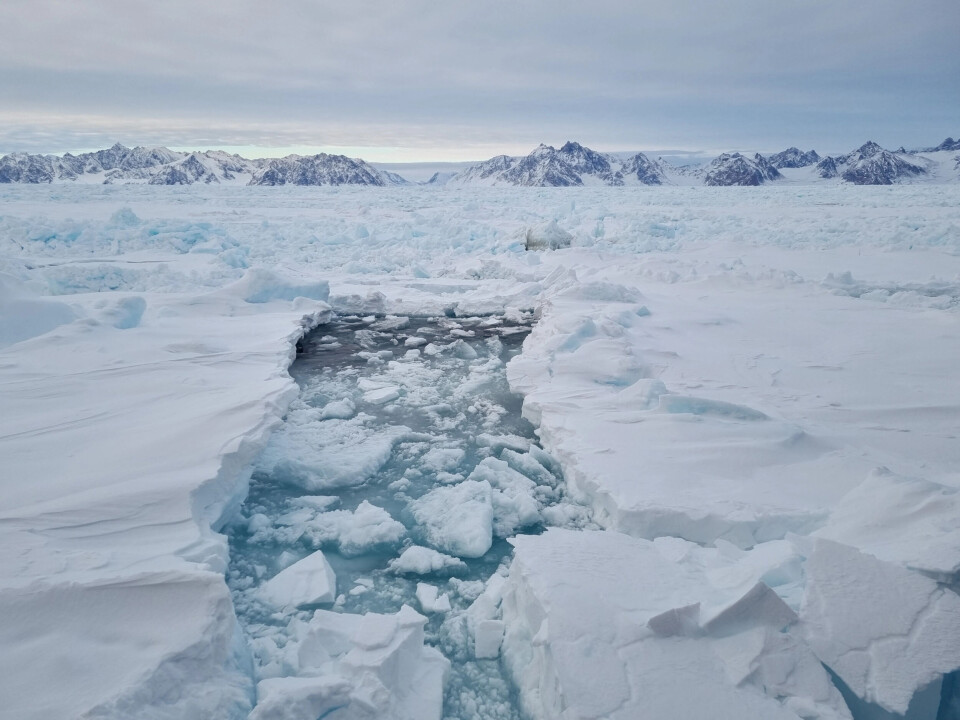
Long swells rock the Greenland Sea. The clock is nearing midnight, and the icebreaker Kronprins Haakon has stopped. Under a crane on the deck hangs a basket with two men. The crane swings the basket over the railing, out over a carpet of ice and black leads. Leads are large fractures in sea ice.
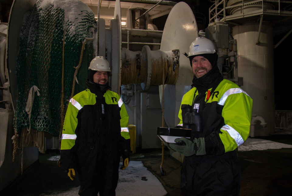
The basket is slowly lowered onto a nearby ice floe. Inside, Anton Korosov crouches, leans forward, and places a box in the snow. He screws it into the ice and brushes snow around its edges. Then the basket is raised, and the two men inside are lifted back on board.
The ice floe glides out of the ship’s spotlights and vanishes into the night.
The box that Anton Korosov and his colleague Artem Moiseev have deployed is a drift buoy that should follow the current southward. On its journey, it will send data back to the researchers at the Bjerknes Centre and the Nansen Environmental and Remote Sensing Center.
Together with seven other drift buoys they have deployed in the last week, this one will help solve a centuries-old problem sailors have faced: finding the best route through sea ice.
Amundsen was heading north
Roald Amundsen aimed to be the first to reach the North Pole, and in 1909 the preparations were in full swing.
In the mid-1890s, Fridtjof Nansen had let the ship Fram freeze into the ice north of Siberia, hoping it would drift across the Arctic Ocean. The ship withstood the freezing well, and now Nansen and the Norwegian state had let Amundsen borrow Fram for a similar expedition.
The plan was to sail north from the Berling Strait, let Fram freeze in, and drift with the ice until it emerged through the Fram Strait. The expedition would take three to five years – a long time both for the men onboard and the families waiting back home in Norway. If the crew found a lead far enough north before the ice trapped the ship, it could save them a year at sea.
You have to go high to see far. From the lookout barrel atop Fram’s mast, an observer could detect leads that could not be spotted from the deck. But even in good weather, visibility rarely exceeeded 10 kilometres. Could they go even higher? Could they see the ship and ice from above?
A forerunner of satellites
Airplanes were too expensive, and Fram too small. Even a balloon, like the one a German expedition had brought, was out of the question.
During the expedition, Amundsen’s men would not only reach new latitudes but explore the Arctic Ocean and conquer scientific territory. Both the royal family and the Norwegian Parliament supported the expedition financially, but resources were still limited.
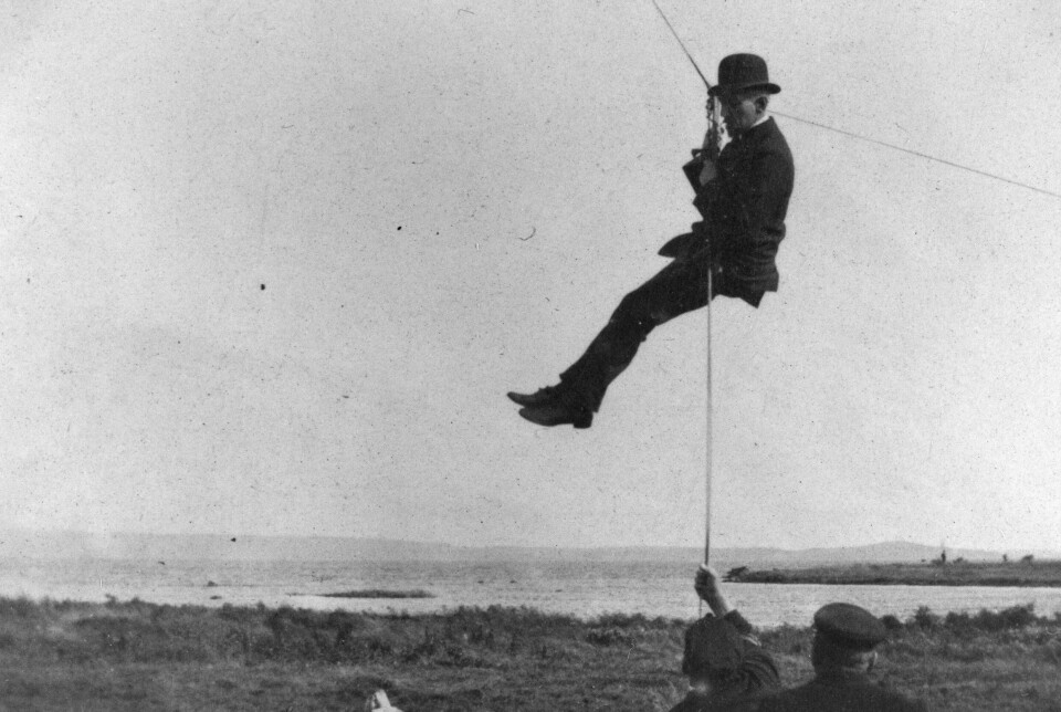
In spring 1909, aviation pioneer Einar Sem-Jacobsen offered a cheaper, lighter alternative.
Kites. Not just one – a kite train.

500 metres above ground, a man floated in a canvas gondola. Above him, a small steering kite, four medium lifting kites, and a large lifting kite of 20 square meteres, formed a kite train, all connected by a single line to the ground. A gentle breeze was all the kites needed to lift a man. In stronger wind, two could be lifted.
The kite trains were tested in rain, wind, and storms. 'If one kite was a little unruly, the others held it back,' Sem-Jacobsen writes in the book Til veirs på norske vinger (Soaring on Norwegian wings). No unpredictable jerks, no sudden dives.
In September, the kites where packed to be loaded onto Fram. From above, like a seagull, Amundsen’s men would be able to see ice floes and open leads far away, perhaps far enough to lead them over the North Pole.
Satellites show the way
“When the ice presses in, you're trapped like in a vice,” says Hallgeir M. Johansen, captain of Kronprins Haakon.
He smiles from his chair. Just the other night, it took a whole hour to move half a nautical mile – about 900 metres.
“Then the first mate came on watch. After 15 minutes, it was as if everything opened up,” he says.
The captain does not attribute all the credit to the watch change. The current was strong, the ice drifted rapidly, and with the current from the side, even an icebreaker can get stuck. When the wind, current, or tide shifts, the ice lets go.
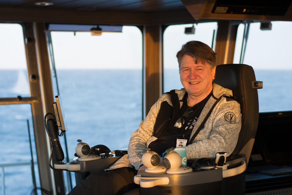
“When you're in the ice, it’s as if everything is quiet. But it’s not," he says.
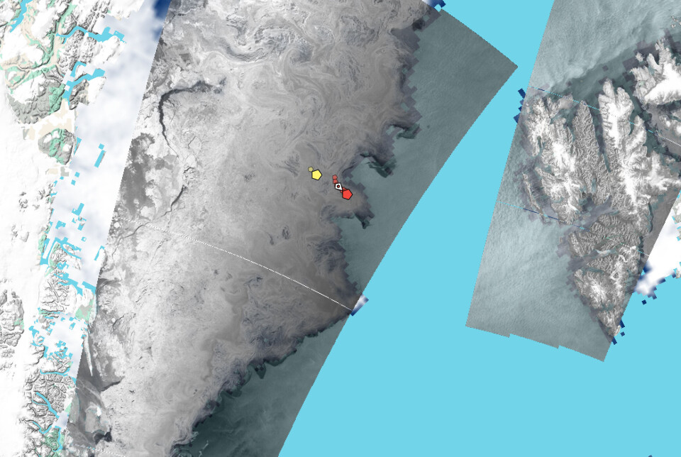
Behind him, a screen shows the latest satellite image of the ice. In some areas, the ice is tightly packed, while others show open paths between ice floes. These images, along with maps showing the ice concentration, provide an overview Roald Amundsen’s men could only dream of.
Avoiding ice is no aim
Captain Johansen’s aim is not to avoid the ice but to find a way through it.
Kronprins Haakon is on a research expedition in the Greenland and Iceland Seas. From the Fram Strait, it zigzags south to Iceland, crossing back and forth over the East Greenland Current, moving between ice and open water.
A couple of days may pass between each satellite image, and the images show only the conditions at the exact time when the satellite passed overhead. Any changes since then must be deduced by the bridge crew. Ice can drift into pigtail-like patterns. In the moment, the crew must rely on the ship's ice radar and their own eyes.
“It’s like sailing with a paper map and no GPS. You have to estimate where you are relative to the ice,” says Johansen.
His biggest wish? More frequent satellite images. But in the future, computer models might help find navigable leads more easily.
Predicting the ice cover
Anton Korosov and Artem Moiseev are back inside and busy analysing the data. The buoy they deployed will help improve the Nansen Center’s numerical sea ice model. In Bergen, simulations are used to study how sea ice forms, breaks, and drifts – and to predict how it will change in the coming days, like an ice forecast.
Together with satellite radar data, the buoys help test how accurately the model reflects real conditions. This is key to making better forecasts.
The model includes how ice freezes and thaws, how it's moved by wind and currents, how it cracks, piles into ridges, and where it ends up.
“As soon as this is in place in the model and in operational forecasts, it could benefit mariners, whether they’re sailing on icebreakers or on vessels that need to stay away from the ice,” says Korosov.
Their forecasts are already part of the EU's Earth observation programme Copernicus. The forecasts are freely available, and their information is used when creating the ice charts that are regularly sent to ships trafficking the northern regions.
But mariners are asking for even more detailed predictions.
So many things can go wrong
Cracked ice floes are forced aside as Kronprins Haakon plows through. White snow slides into the ocean, while shiny blue ice comes to the surface. Earlier on the trip, the swell pushed the ice 150 kilometres into the ice pack. Waves and storms can break up entire regions of ice.
What can go wrong for a small box on an ice floe? Korosov and Moiseev list a few:
- Bad batteries
- Frozen electronics
- Humidity and icing
- Broken by bears or seals. This has happened before
- Crushed between ice floes
“As long as the buoys float, they are not lost,” says Anton Korosov.
May drift for several months
When they were to deploy the last buoy, the swell was too high for them to go out in the basket. No matter how advanced electronic instruments become, the real world demands dexterous hands. A buoy drop from the crane was prepared in Kronprins Haakon’s workshop.
“We took a piece of a Euro pallet and left screws sticking out underneath it,” says Korosov.
The buoy got a wooden raft. If it ends up in a lead, the raft might keep it drifting.
The batteries last for four months. With a bit of luck, that is long enough for the buoy to be tracked on its ice – or wood – floe to the southern tip of Greenland, showing where and how fast the ice moves.
While such research may make it easier for captains to find navigable leads in the future, research vessels like Kronprins Haakon will still head into the ice, just like polar researchers and explorers always have.
Amundsen lied
Amundsen never went to the North Pole. He tricked everyone and steered Fram towards Antarctica, where the sea ice is less challenging to navigate. From the base Framheim in the Ross Sea, he headed for the South Pole with dog sleds and skis.
The kite trains were never used. There was no need to become seagulls. But part of the equipment came in handy when over a hundred Greenland dogs were brought ashore. Outside Framheim, the dogs were tied to a line that had once been Amundsen’s only connection to the Earth.
References:
Arnesen, O. & Sem-Jacobsen, E. Til veirs på norske vinger. Af flyvningens historie i Norge (Soaring on Norwegian wings: A history of aviation in Norway), Gyldendal Norsk Forlag, Oslo, 1930.
Korosov et al. Tuning parameters of a sea ice model using machine learning, Geoscientific Model Development, vol. 18, 2025. DOI: 10.5194/gmd-18-885-2025

This content is paid for and presented by the University of Bergen
This content is created by the University of Bergen's communication staff, who use this platform to communicate science and share results from research with the public. The University of Bergen is one of more than 80 owners of ScienceNorway.no. Read more here.
More content from the University of Bergen:
-
Researcher discovered that migrants lived more stable lives in the USA than in Norway
-
A brutal field trip gave researchers new insight into Arctic winters
-
Your rain gauge could help improve weather forecasts
-
How one genetic error can affect both the heart and the brain
-
80 per cent of life in Arctic sea ice may be hidden here
-
Conflict over maritime areas: China adapts its messaging to different audiences


