An article from Norwegian Geotechnical Institute

Helicopter sensor improves Arctic ice volume surveys
New technical equipment and software help measure sea ice thickness in the Arctic Ocean.
Denne artikkelen er over ti år gammel og kan inneholde utdatert informasjon.
Until now, scientists and climate experts have been facing a great challenge due to the fact that they could only estimate the sea ice’s surface elevation or draft, not the total ice thickness and consequently volume.
”The extent of ice on the surface can be surveyed relatively easily, while it is more complicated to estimate the total mass of ice. And it is the total ice volume which is significant for everyone studying climatic change,” says Andreas A. Pfaffhuber, project manager for MAiSIE and head of geosurveys at NGI.
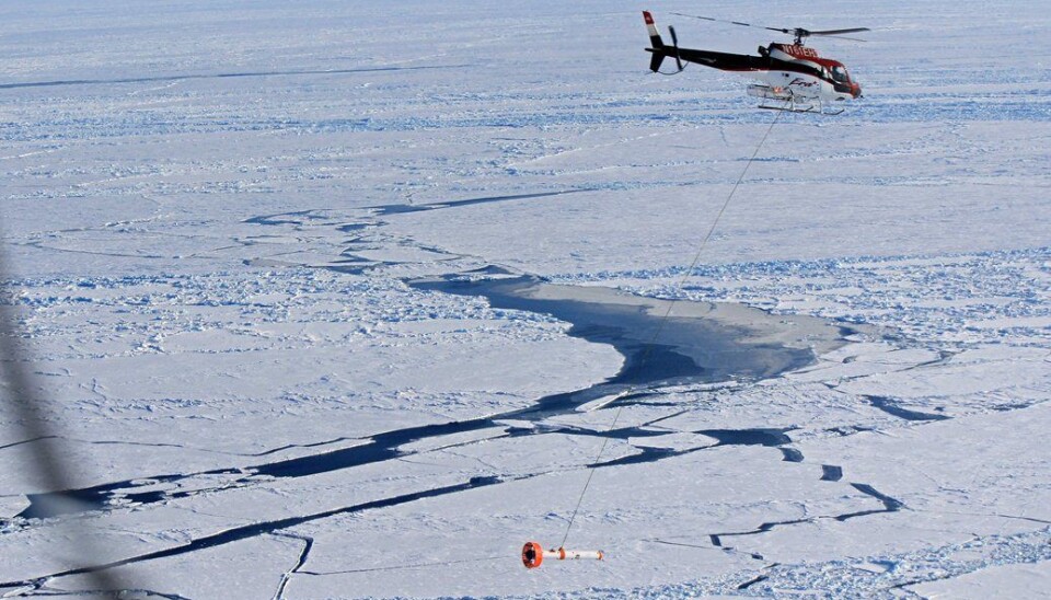
MAiSIE is a Multi-sensor Airborne Sea Ice Explorer that was developed to measure the thickness of sea ice. The torpedo shaped system, 3.5 meters long and weighing approximately 100 kilograms, is packed with highly advanced electronic equipment and measurement systems.
Electromagnetic sensors measure the distance to sea water underneath the ice, while lasers gauge the distance to the ice- or snow surface.
Last winter, Norwegian Geotechnical Institute (NGI) did a major upgrade of technical equipment and software on board MAiSIE.
Polar waters
Early April 2013, the unit with all its advanced instrumentation was brought to Alaska, where it is being used by researchers from Alfred Wegener Institute for Polar and Marine Research (AWI) to measure sea ice thickness in the Arctic Ocean.
After this campaign, based in Barrow, MAiSIE will be taken far south to map the volume of Antarctic sea ice from June until October, operating from the German research vessel Polarstern.
The outcome will most likely be more accurate measurements and more details regarding the total ice volume in Polar waters during the coming season, with possible consequences for a number of climate issues.
During spring 2012, MAISIE was first applied in a campaign, based in Barrow in Northern Alaska. During summer, the system was used from the research vessel Polarstern and its on-board helicopter. The instruments are installed on board the device also known as a bird, hanging 10–15 meters above the sea surface.
Three dimensional data
One of the most important improvements, compared to the earlier version, is the simultaneous use of several electromagnetic signals frequencies, received in all horizontal and vertical directions, resulting in accurate three dimensional ice thickness data.
Another important improvement is an advanced system of sensors monitoring pitch and roll and enabling computations to compensate for inaccuracies caused by these changes in attitude.
”Last year we saw that some of these systems were influenced by changes in air temperature. After having upgraded the instruments and software on board MAiSiE, we have succeeded in reducing and partly eliminating these inaccuracies,” says Pfaffhuber of NGI.
As a result, the Alfred Wegener Institute now has significantly more accurate methods for surveying ice thickness and volume this summer season of 2013. The improvements will be especially significant in ridged areas. Sea ice ridges can go as deep as 20 meters under the surface. Especially these structures were underestimated by conventional EM ice thickness devices so scientists have had difficulties surveying areas with many and large ice ridges.
“We expect growing interest in MAiSIE from research institutions as well as commercial players the next few years, resulting from increased interest in the Arctic regions, climate issues in general and ice surveys more specifically,” says Pfaffhuber.
A need for smaller versions
One of the new application areas of MAiSIE, as expected by NGI, is the use of a modified, miniature version, for example applied from icebreakers during navigation in ice covered waters enabling crew to monitor ice thickness and possibly dangerous ice ridges in real-time.
The ultimate development goal is to reduce weight and size of such systems for the use with UAVs (unmanned aerial vehicles), opening up opportunities to survey large areas in a safe and efficient way.
The team who developed MAiSIE, mainly financed by the Alfred Wegener Institute, includes Andreas Pfaffhuber, Yme Asgeir Kvistedal, Erik Lied, Ivar-Kristian Waarum, Philip Hayes and ten other NGI employees.


