This article is produced and financed by University of Oslo - read more
The Earth’s coldest permafrost is in a mountain in Antarctica
The first map of permafrost distribution in the Northern and Southern hemispheres has been developed by researchers from UiO with help of satellite data and a new model. The very first global estimate of permafrost temperatures reveals that the coldest ground on the Earth is found in the Transantarctic Mountains.
Permafrost is a subsurface phenomenon that underlies a significant part of both the land and sea at the high latitudes in Northern and the Southern hemispheres. Permafrost is defined as ground which remains below 0 °C for at least two consecutive years.
The temperature in permafrost varies considerably from place to place. For example, permafrost measured in Northern Norway has a temperature of just under 0 °C, while permafrost in Siberia in Russia is colder and is below -10 °C degrees.
An important storage for ancient carbon
Permafrost acts as a freezer for dead organic matter that has accumulated in the Arctic over centuries. It is estimated that permafrost stores nearly twice as much carbon than is currently present in the atmosphere, according to a study from 2014.
Permafrost also affects the stability of bedrock and unconsolidated sediments, and thawing of permafrost impacts the costs and methods used for infrastructure development, revealed by research in several studies.
“Permafrost thaw will likely have a profound influence on our future global climate. The organic matter stored in permafrost will be decomposed if it is thawed and released to the atmosphere as greenhouse gases CO2 or methane. Despite its importance for the climate we know very little about permafrost outside areas where permafrost temperatures are measured in boreholes,” explains Jaroslav Obu. He is a researcher at the Department of Geosciences, University of Oslo, and is the first author of two new studies about permafrost.
Studying the permafrost from space
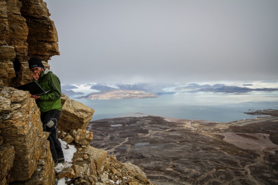
“As permafrost is an underground phenomenon, it is difficult to study it without drilling into the ground. We had to find a way to reliably record permafrost on a global scale. We developed a method that takes advantage of land surface temperature observed by Earth observation satellites, which we used in a permafrost model that estimates temperatures deeper in the ground,” says Obu.
The first step was to find the permafrost distribution in the Northern Hemisphere. They used an equilibrium state model (TTOP-model) to compute temperatures in the top layer of the permafrost for the period 2000 to 2016. The main model input was remotely-sensed land surface temperatures that are provided daily by the Terra and Aqua satellites. Snowcover and ground properties, which have an important influence on permafrost properties, were estimated from the ERA-Interim climate model and from the Landcover Climate Change Initiative/ESA.
With this model and data available for each square kilometer of the Earth’s surface, they were able to calculate a global permafrost map showing permafrost temperatures where boreholes do not exist. The figure below shows that the permafrost temperatures decrease from 0 °C (green colors) towards high north latitudes in Siberia, Canadian Arctic and Alaska – which are covered in purple and pink, indicating that the temperatures in the permafrost vary from -7 to -14 °C.
The lowest modelled permafrost temperature in the Northern Hemisphere was -22 °C in Northeast Greenland.
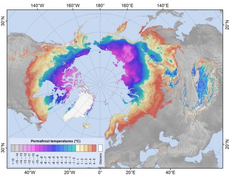
The distribution of permafrost and temperatures in the ground in the northern hemisphere. (Figure: Obu, J. et al. 2019. Interactive map/AWI)
The model performance was compared to permafrost temperatures actually measured in boreholes around the globe and the accuracy was ±2°C. They found that the modelled extent of the permafrost in the Northern Hemisphere covered 13.9×10 km2 (c. 15 % of the exposed land area), which was within the range or slightly below the average of previous estimates.
The lowest permafrost temperature on Earth
In the second study, the research team used the same approach to investigate the ice-free areas in the high latitudes in the Southern Hemisphere – The Antarctic. This huge continent covered mostly with ice has some of the lowest air temperatures recorded on Earth. The Soviet Vostok Station on 21 July 1983 recorded −89.2 °C. In 2010 satellite observations recorded a surface temperature of −93.2 °C (Wikipedia).
Although there is only 0.2 % of the Antarctic that is not covered with ice, these ice-free areas are distributed around the whole continent from the coasts to mountain peaks rising above 4000 meters. Permafrost is present under almost all of these areas, but little was known about variations of permafrost temperatures outside a few areas with established ground temperature measurements.
The researchers investigated the ice-free areas of the Antarctic mainland and islands at 1 km2 resolution for the period 2000–2017. The results from the TTOP-model were checked against temperatures from 40 permafrost boreholes and the accuracy was ±1.9°C.
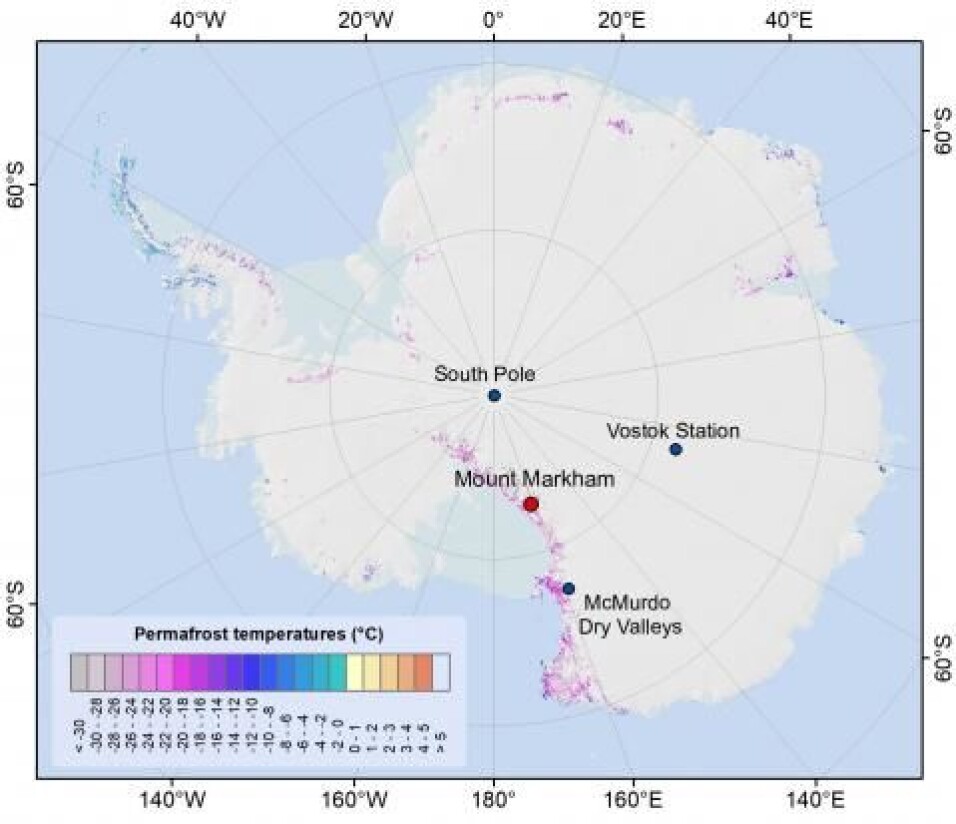
The distribution of permafrost and ground temperatures in Antarctica. Mount Markham is marked with red and is in the north end of the Markham Plateau. (Figure: Obu, J. et al. 2020. Interaactive map/AWI)
“The modelling results show that the lowest estimated permafrost temperature of −36 °C is on Mount Markham in the Queen Elizabeth Range of the Transantarctic Mountains. This is so far the lowest estimated permafrost temperature on the Earth.”
The other temperatures were most commonly modelled between −23 and −18 °C for mountainous areas rising above the Antarctic Ice Sheet, and between −14 and −8 °C for coastal areas.
Comprehensive research efforts
This research is built on a comprehensive work from an international team of researchers. The first study, "Northern Hemisphere permafrost map based on TTOP modelling for 2000–2016 at 1 km2 scale", was published in the journal Earth-Science Reviews in June 2019.
The second study, "Pan-Antarctic map of near-surface permafrost temperatures at 1 km2 scale", is recently published in The Chryosphere. This is an online scientific journal where the articles are the subject for discussion in the worldwide cryosphere research community before final printing, as this article was in February 2020.
Finally the two studies are using data from boreholes and observations from a researcher network's efforts coordinated within The Global Terrestrial Network for Permafrost.
References:
J. Obu et.al: «Northern Hemisphere permafrost map based on TTOP modelling for 2000–2016 at 1 km2 scale». Earth-Science Reviews, Volume 193, PP: 299-316.
J. Obu et.al: «Pan-Antarctic map of near-surface permafrost temperatures at 1 km2 scale». The Cryosphere, 14, 497–519, (2019). https://doi.org/10.5194/tc-14-497-2020, 2020.
———
Read the Norwegian version of this article at forskning.no